Dear Experts,
Please, does anyone have a software, module, etc… that can help map Traffic volume per Cell/Sites on Google Earth?
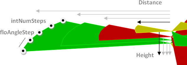
Same as showing Timing advance or Propagation delay per cells on Google Earth.
Thanks.
Dear Experts,
Please, does anyone have a software, module, etc… that can help map Traffic volume per Cell/Sites on Google Earth?
Same as showing Timing advance or Propagation delay per cells on Google Earth.
Thanks.
Have you checked the tools available here at our Community?
There’s sample apps, inclduing to plot TA/Propagation Delay:
Any planning software should be able to do this (e.g. Atoll, U-Net, Planet), QGIS or Mapinfo might be able to do it as well with some workarounds.
However, I came across an Excel macro that may help you in TP/TA.
3G-Macro: TP Dashboard and Geographical Users Distribution
I know for the Planning Software, just wanted to plot on Google Earth.
As additional module or app for google earth.
Thanks for the MACRO.
Thanks @leopedrini, great, I’ll check it out too.
For Planet, it is already embedded.
Not sure about the others.
Thanks Leo
This is fantastic.
I will check it out and get back to you.
Bless you sir
Ok fine. Right I have a similar macro showing 3G distance with user distribution.
Thanks, I ll try yours too.
Thanks Sir
Sam : Can we have Macro that relates 4G TA with its RSRP ,SINR ,RSSI value like that of 3G(TP With RSCP and ECNO)