Hi Experts.
Can anybody explain how KPI Monitoring could be done with the help of Google Earth?
Hi Experts.
Can anybody explain how KPI Monitoring could be done with the help of Google Earth?
What you mean?
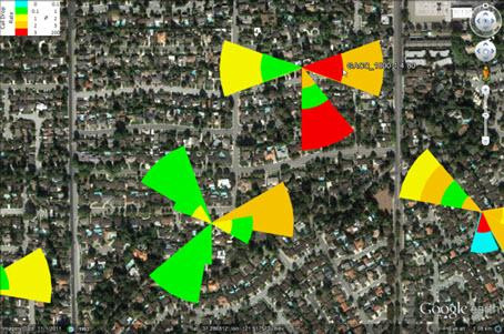
There is one way: generating a *.kmz file every day with the information you want.
The generation of this file can be done both ways manually and automatically
You can start doing some polygons and then creating sectors.
With those polygons you can add label, legend or information that can be pop up with a click.
You can also control polígon colors in order to get the KPI range under monitoring.
But this is kind of no flexible.
For every KPI to monitor needs a new kmz file generation.
OK. So generating kmz is time taking?
And is it effective from traditional manual KPI monitoring?
Depends on the information you put in it.
You can do it by Visual Basic (Excel) also by Python.
Easier to implement.
It depends on your experience and knowledge. At the end of the day this is another tool.
Is this method implemented for KPI Monitoring in any Operator / Country?
This is a complementary tool in several Operators.
It is better to do it in QGIS.
After, if you want, you can pass to kml only that you need.
QGIS means?
QGIS is a free software, similar to Mapinfo:
Do a search here in forum: Search results for 'QGIS' - telecomHall Forum or see this: QGIS - Free and Open Source Geographic Information System
I think that QGIS is a good alternative to Mapinfo.
This is a good solution!
QGIS is Python enabled so you can do scripts for example to find PCI collision and all in every efficient manner.
You can upload performance data like KPI and all and see in geographically on map.
OK.
So can we do connectivity of Google Earth with OSS to fetch KPI’s & counters?
I don’t think so.
Due to cyber security rules with operators.
But what you can do is to import Excel of KPIs in Google Earth separately for thematical presentations and all.
OK. Then how Google Earth could be used for KPI Monitoring?
As I said this a matter of acceptance from Operator end.
What tool they allow to use in their network.
Rare example.
Use QGIS and generate KPIs maps. After, pass to KML.
No more.
You take 30 seconds pass from QGIS to KML.
Perfect. ![]()
And automate with Python.
You don’t.
You connect your KML script generator with your KPI database.
And then the results are *kmz with your KPIs.
Please tell us how to make it, thx