Introduction
Databases: If you have not used, believe, will use! Are very important as an adjunct to many tasks of analysis and reporting.
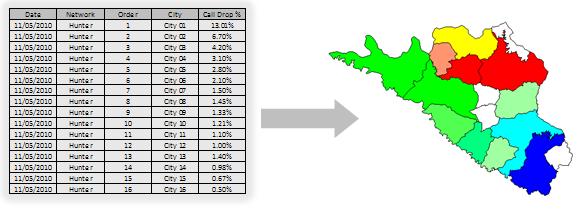
For example, in a report with the municipalities more offenders dropped calls can make a table. But we can make a thematic map. Which is better? Note the picture below and draw your own conclusions.
Databases are also essential tools for predicting how the Asset3g Aircom or x-Wizard of Optimi. In the prediction tools, the databases are the way they “see” the world.
Databases are generally acquired through specialized companies, but there are alternative options, not many people know that allows us to get free lass. That is what we learn today. Let’s take a short break in the scripts for this important step, basic but necessary support to develop other modules.
Note: It is not our purpose here today in deepening the study of GIS software (eg ArcView), other file formats (such as SHP - ArcView Shape of) or still Digital Elevation Models (DEM). Our goal is to provide the minimum information necessary so you can get the basic data shown. No doubt there is much you can explore this area, if they so wish.
Note: Our audience ranges from a student of Telecom by experienced professionals with extensive knowledge in the area. So we ask a little understanding and tolerance are some of the basic concepts presented today are for you. But they are necessary for the joint development of all.
Purpose
The present is an introduction to basic data (altitude, vector, etc …) and an alternative solution to obtain the same, and the procedure to process the data obtained.
Some time ago, finding databases was a difficult task. Returning to the beginning of the projects of cellular networks, the professionals were using printed maps, such that if they buy at newsstands. To analyze altimetry, were usually printed maps with level lines in a given scale. Aerial imagery, today so trivial when we think for example that the images in Google Earth provides free were a rarity. And when they had, they were extremely expensive. The same applies to vectors, such as the boundaries of cities and streets.
Fortunately, today we have a considerable amount of databases and made freely available by various sources. It’s just not that simple to find. But knowing where to look, our task becomes easier.
Let’s see the following two excellent examples of where we can get databases of altimetry (essential for analysis and prediction of transmission) and also vectors.
Note: our audience (telecomhall) is worldwide, and of course we can not cover here to obtain data for all areas covered, especially with the best accuracy available, the If altimetry. But we will show through examples that can be extended to any location. The most important thing is to learn how to treat the raw data obtained for the processed results.
Databases Altimetry (heights)
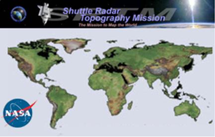
The main example of databases altimetry (heights) free bases have the topology of NASA, obtained by SRTM.
A "SRTM (Shuttle Radar Topography Mission) mission was conducted during 11 days of February 2000, using a specially modified radar system attached to Space Shuttle Endeavour. This mission has obtained elevation data on a near global scale to generate more comprehensive database of digital topographic high-resolution Earth.
addition to the data released by NASA, we also have other sources of databases, such as the Terra-Server server, which provides images (imagery), and a series other fontes.Fique the will to do their own research / downloads.
Heights - NASA (SRTM)
The SRTM data can be obtained directly through the address: http://dds.cr.usgs.gov/srtm/version2_1/ navigating to the directory SRTM.
For more information, updates and releases, bug fixes, etc., please see the online documentation available at the site of the SRTM: http://www2.jpl.nasa.gov/srtm/index.html.
Another download link is http://eros.usgs.gov/ # / Find_Data / Products_and_Data_Available / Elevation_Products .
The following are some paragraphs with enough technical information on SRTM, if you need these details.
SRTM data are distributed on two levels: SRTM1 (for U.S. and its territories and possessions) with data sampled at intervals of one arc second in latitude and longitude ( 30m resolution), and SRTM3 (the world) sampled at three arc second (90m resolution). Data from three arches of a second are generated by an average of three by three samples of an arc second.
Data are divided on the basis of a one degree of latitude and longitude in geographic projection, to show a raster with equal intervals of latitude and longitude in any projection as a whole but easy to manipulate and merge. The datum used is WGS-84.
file names refer to latitude and longitude of lower left corner of the region, for example N37W105 has its lower left corner at 37 degrees north latitude and 105 degrees west longitude. To be more exact, these coordinates refer to the geometric center of the lower-left pixel, in which case the data SRTM3 will be approximately 90 meters in length.
Files height (height files) has the extension. “hgt” and more two-byte integers. The bytes are the order of Motorola "big-endian with the most significant byte first, directly read by systems such as Sun SPARC, Silicon Graphics and Macintosh. DEC Alpha and most PCs use Intel order (little-endian), then some byte swap may be required. The height is in meters referenced to the datum WGS84/EGM96. Data gaps are designated with the value -32 768.
SRTM3 files contain 1201 lines and 1201 samples. The lines of the edges north and south, as well as the columns of the east and west edges of each cell are identical to overwrite and rows and columns from the edge of adjacent cells.
SRTM1 files contain 3601 lines and 3601 samples, with overlap similarly.
You can also download the SRTM geographical basis already in UTM projection and datum WGS-84, which facilitates their subsequent use in prediction systems, which will be our case.
Heights - Comparisons with bases paid
Although NASA data have a resolution of 90m, often the result is better than some commercially available databases with lower resolution.
This is because a commercial basis may have been obtained from sources not as accurate as 1:50,000 maps from IBGE.
Importantly, the raw data of the SRTM could be pre-processed, since they have some problems such as discontinuities, voids, no flushing water bodies, etc..
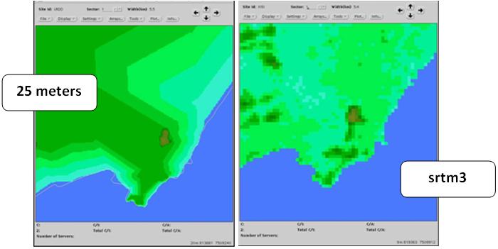
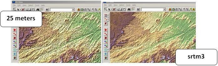
Preliminary analysis of data SRTM3 (with 90m resolution) repeatedly shows a detail somehow BETTER than the altimetry data from commercial, for example, 25m.
This can be seen in the figures below.
Heights - Procedure for Obtaining Data
Well, now we know that we can use the databases of NASA with reasonable accuracy, let’s see the procedure for obtaining them.
Note: The form shown is not the only possible. Especially if you have skills with GIS software. Is up to you to choose the most appropriate in your case, taking into account mainly the precision you need.
The best solution, and faster to process data is using the Global Mapper software. This is an excellent assist GIS software, and can be downloaded in its trial version. The only problem is that the trial version does not allow saving files, or does not work in our case.
Anyway, we could not fail to mention it here, and will soon publish a tip with examples of use of its trial version, which does not cease to be interesting, for example to view profiles of transmission. Global Mapper can read almost all formats of GIS files. And in your registered version, you can convert them to another format qualuqer.
The trial version of Global Mapper can be obtained from the manufacturer’s website: Download Global Mapper NOW.
Unfortunately, as we will not use the Global Mapper - since we only use free software or trial with all features - we have a little more work, but to see how.
Heights - Downloading a file HGT
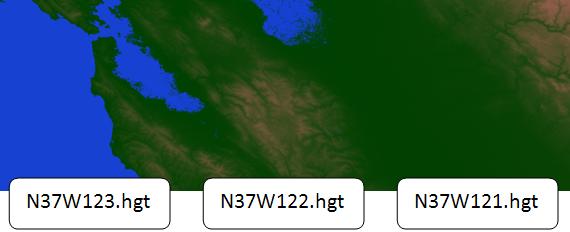
First, we download a file in HGT. Before downloading the files, we need to know the coordinates needed. For our fictional network, a good example is the file with latitude 37 and longitude -122.
Note: The filenames represent lower left corner of your map. The naming convention is (N or S) xx (W or E) xxx.hgt. In our case, we will download the file that covers the region from latitude 37-38 degrees North and longitude 122-123 degrees West. So, let’s download the file N37W123.hgt. Just as another example, in the southern hemisphere S17E142.hgt file covers the region from latitude 16-17 degrees south and longitude 142-143 degrees East.
First, let’s download the file N37W123.hgt. Enter your starting address, and click SRTM3.
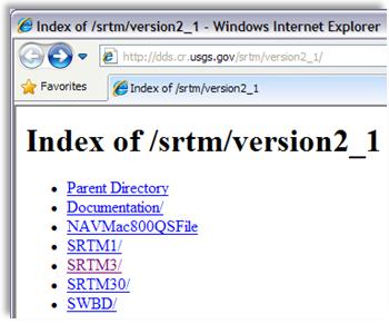
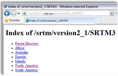
Then click in North America.
In the next window, locate the desired file N37W123.hgt, right-click and save it in C:\Hunter\Data\SRTM\ (create this directory using Windows Explorer).
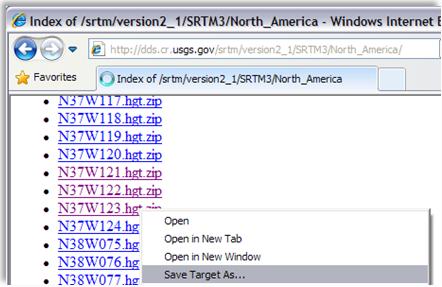
Note: The file type is downloaded is compressed (ZIP), so extract the original file for that folder.
Unfortunately, the format HGT is not opened directly by any of the major GIS software such as MapInfo, ArcView or Prediction. So we must save it in a format DEM - Digital Elevation Model, which is read by most commercial software.
Heights - Converting one file HGT to DEM
As mentioned earlier, the Global Mapper does it with ease. But as we have the registered version of Global Mapper, we will use a software utility to do this conversion: the 3dem.
So, first download and install the 3dem through the link: http://www.softpedia.com/progDownload/3DEM-Download-111975.html . Installation is simple.
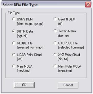
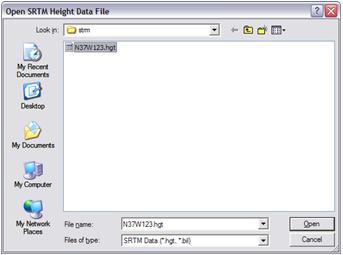
After installing, start 3dem. Once started, the program asks what type of file you want to open. Select Date SRTM (hgt, bil) and click the OK button.
Then navigate to the directory where you downloaded the file (C:\Hunter\Data\SRTM) and click Open.
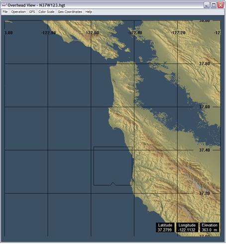
The data can now be viewed in the program interface 3DEM.
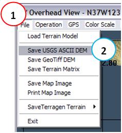
We now save the HGT to DEM format. To do this go to Menu: File (1) → Save USGS ASCII DEM (2).
To keep the reference, save this file with the same name as the original file (the extension but now it will be DEM).
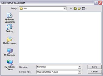
Ready, the DEM file has been saved! Close the program 3DEM.
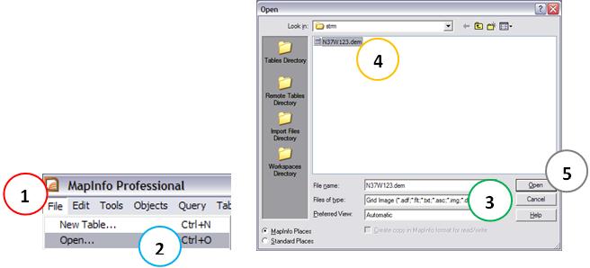
And now let’s open the file in MapInfo. To do this, go to Menu: File (1) → Open … (2), select files of type GRID Image (3) navigate to the directory where the files are as mentioned above by selecting the same (4) and click the Open button (5).
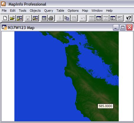
The result is shown. Note that each point has a height information, you can see this by passing the mouse over any point.
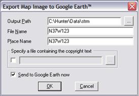
Finally, use the tool Gelink, as we saw in the previous tutorial, and save the result as a KML file (Google Earth).
The result as seen in the following figure is quite satisfactory.
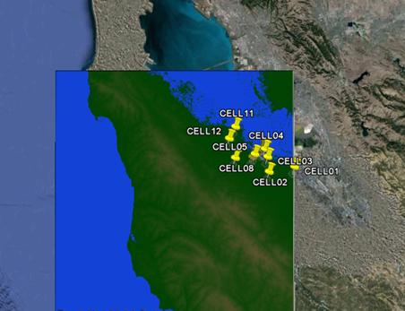
NOTE: It is clear that the base is not perfect. But it is an excellent approach, and depending on your type of work is more than enough.
We could have used instead of srtm1 srtm3, then we would have an even better result. However, as srtm1 not available for everyone, we prefer to use the global statement that it might be used for whatever the location of your network. If your network is located in the United States, use version 1.
You can repeat the procedure to complete the entire length of your network. Below is the result for the files N37W121.hgt, and N37W122.hgt N37W123.hgt together.
Final consideration: the solution shown is not the best, but achieves the goal with just a little more work - we have to open each file one by one. The intention was just to demonstrate that we can obtain and handle databases with considerable precision altimetry. Feel free to seek alternative solutions, and in case of problems, contact our support.
Databases Vectors
Like altimetry databases, the databases of vectors are also useful, and can also be obtained free of charge.
There is entering a single repository where we can find vector maps of the world. The best place to find the same sites are often in local government. In Brazil, we will use this demonstration, an excellent site is the site of IBGE.
IBGE is an institution that provides various data, but unfortunately the site structure for disclosure lacking. For those who never used it is common to spend hours browsing to find the product you are looking for. So, follow the steps to download the state or of any Brazilian city. The vectors are in SHP format, a format that can be opened by Argis, Mapinfo or similar program.
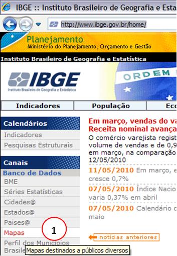
To begin, visit the IBGE: http://www.ibge.gov.br/ and click on Maps (1).
Then click on the link Databases and Benchmarks.

This section is aimed at users who already have familiarity with the use of GIS tools and geospatial databases that need to implement various projects. It is available geospatial vector data files, on different scales and formats, and files geospatial raster (picture cards, orthophotos, digital elevation model), aerial photographs in JPG format, letter in PDF format, and the networks of the System Brazilian Geodetic to query, download and print.
Further, refer to the Basis of Geography.
![]()
this section are related cartographic databases with several areas covered in various formats and scales.
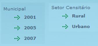
Finally, visit the link Mesh Digital.
![]()
The Knitting Digital constituted of vector files in formats DGN - not tied to databases - and SHP - linked to the database, with the division of mesoregiões, the microregions, municipalities and census tracts. For the year 2007 are available municipal meshes in the geographic coordinate system and projection Policônica, and the scales 1: 500,000, 1:1,000,000, 1:2,500,000. The meshes of the census tracts are divided into urban and rural sectors, which complement each other.
In each of the links you find the vectors in the SHP format, Arcview, but we’ve seen can be read by MapInfo.
Accessing Municipal 2007 link you find data vectors of Brazil showing the states, and also vectors for states with limits of municipalities.
Accessing the link Setor Urbano you find data vectors Neighborhoods. Unfortunately, there is complete breakdown of neighborhoods for all existing municipalities.
The following are direct links.
Brazil States (UF):
ftp://geoftp.ibge.gov.br/mapas/malhas_digitais/municipio_2007/Malha_Municipal_Digital_2007_2500/Disseminacao_2007/Proj_Geografica/SAD_69/ArcView_Shp/2007/E2500/UF/
Neighborhoods:
ftp://geoftp.ibge.gov.br/mapas/malhas_digitais/setor_urbano_2007/
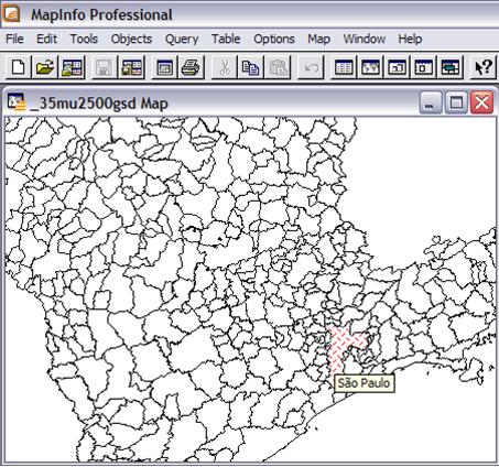
We demonstrate, for instance, obtaining the vector data of the State of São Paulo, and its municipalities.
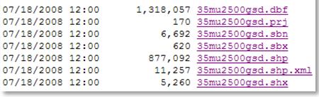
First, access the Link State (PSU) as shown above, choose the UF SP, and download all the files to the directory C: \ Hunter \ Data \ ibge \ UF \ (you must first create this directory).
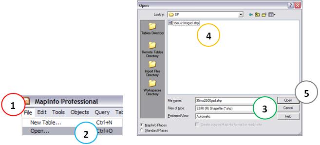
Then start the MapInfo and access the menu: File (1) → Open … (2), select files of type ESRI ® Shapefile (3), navigate to the directory where the files are as mentioned above by selecting the same (4) and click the Open button (5).
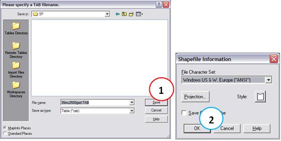
For organization, save the file tab in the same folder where the other downloaded by clicking the Save button (1) and the OK button (2) in the new dialog box that arise.
There, the data are already available.
This was a demonstration of how to get vector data from Brazil from the site of IBGE.
Other Locations and Types of Maps
As already mentioned, the types of data and maps will depend on what you need or want.
If you have other interests, such as highways and railways, the ideal is to look for maps on the website of the Ministry of Transport (http://www.transportes.gov.br)
Access Maps and Information, then Maps Transport, then State Editable Maps (AutoCAD fomat 14). Or visit http://www2.transportes.gov.br/bit/01-inicial/index.html.
Another site with interesting data is the IBAMA. Accessing http://siscom.ibama.gov.br you find files in SHP format of almost all regions, and also data on deforestation, and Georeferenced Images and georeference Landsat and CBERS orthorectify. On the website of the Ministry of Environment also has some information.
As it showed me there is a plethora of places where you can find maps best suited to your work.
If you have any questions, please contact our support and help, for example with some more specific link.
Links
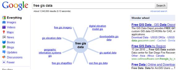
If we were to include here links to all the free databases available, covering the entire globe and all types and formats available, surely we would have hundreds and even thousands of links. And this is not the goal. Therefore, we suggest you do a Google search using for example “Digital Maps” and the name of the country where your network is located. If you do not succeed in your search, please contact our support.
Below, a result of Google (enabling the feature magic wheel), showing the huge amount of data available, often unknown to the vast majority of people.
Conclusion
In this tutorial we know what’s GIS databases and how to obtain them for free by searching the web. We saw how to download altimetry data to any location worldwide with reasonable accuracy, which can be used in prediction tools and transmission. We also saw how to download vector data (boundaries of states, cities, neighborhoods) in Brazil. Because there is no one single location (site) with vector data covering the whole world, those data to other locations or even other types of data for Brazil is up to you. The most important is that we show how the process generally.
Increasingly, the databases are becoming more affordable. One example is Google Earth, which provides free bases altimetry, vectors, and other pictures in your program.
Hope you enjoyed it. Ask any questions posting your comments in the blog or via our Support via Chat or Email.
Until our next meeting and remember: Your success is our success!
Download
Download Source Code: Blog_009_Digital_GIS_Data.zip (5.9 MB)