Hi Experts.
Does anyone know how to convert coordinates from RBS format to decimal in Ericsson systems?
Hi Experts.
Does anyone know how to convert coordinates from RBS format to decimal in Ericsson systems?
To convert RBS (Rational Based Seconds) values to decimal degrees for latitude and longitude, divide the values by 3600.
Calculation:
\text{Decimal Latitude} = \frac{227463}{3600} = 63.18417
\text{Decimal Longitude} = \frac{-2550440}{3600} = -708.45556
Result:
Latitude: 63.18417
Longitude: -708.45556
I hope it is correct
Thanks, but the longitude cannot be -708.4.
Hi, I got a weird formula that I have no idea where it came from, but I’m currently using…
latitude * 93206.7 and longitude * 46603.4
The struct has also the latitudeSign to point in which position of the equator you are placed. It worked…
But as I mentioned before, those numbers are black magic ![]()
===========================================================
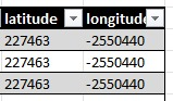
RBS format :: 227463 [A] & -2550440 [B]
Convert from RBS to Lat/Long format
=(A90)/2^23 = 2.440413237
=(B360)/2^24 = -54.72650528
===========================================================
Lat/Long Format :: 2.440413237 [C] & -54.72650528 [D]
Convert from Lat/Long to RBS format
=(C2^23)/90 = 227463
=(D2^24)/360 = -2550440
===========================================================
Hope this will help you.
Yes, if you are using Atoll, you need to use the correct conversion tool.
There is a website that can accurately handle both single and batch coordinate conversions.